Awards and Recognitions

IBM Champion Awards - 2024
Congratulations to all the new and old IBM Champions for 2023. Honored to be part of this group as a Lifetime IBM Champion. Lester Knutsen received the Inaugural IBM Champion award when it was launched in 2008, and he has received the award every subsequent year.

IBM Champion Awards - 2022
Congratulations to all the new and old IBM Champions for 2022. Honored to be part of this group as a Lifetime IBM Champion. Lester Knutsen received the Inaugural IBM Champion award when it was launched in 2008, and he has received the award every subsequent year.

IBM Champion Awards - 2021
Congratulations to the following Advanced DataTools team members - just announced by IBM for the 2021 IBM Champion Award! These team members have been selected as IBM Champions every year since 2014:
- Thomas Beebe (Tom's Acclaim badges)
- Art Kagel (Art's Acclaim badges)
- Lester Knutsen (Lester's Acclaim badges)
- Mike Walker (Mike's Acclaim badges)
We are also proud that
- Art has received the IBM Champion award yearly since 2010.
- Lester Knutsen received the Inaugural IBM Champion award when it was launched in 2008, and he has received the award every subsequent year.
From the IBM website, the IBM Champion award signifies “proven innovative thought leader in the technical community who has demonstrated exceptional expertise and contribution in helping others derive greater value from IBM software, solutions and services.The badge recognizes the IBM Champion’s skills not only in the Champion’s area of technical expertise, but also as one who influences and mentors others through blogging, speaking at conferences, moderating forums, leading user groups, and authoring books or articles.”

IBM Champion Lifetime Achievement Award to Lester Knutsen
Lester Knutsen was honored to receive the IBM Champion – Lifetime Achievement Award from IBM on September 1, 2020. View his verified achievement from IBM.

IIUG Directors Awards
The IIUG Directors Award honors user group members who have made outstanding contributions to promoting Informix and the International Informix User Group, and who generously share their knowledge and skills with the wider Informix user community.
- Tom Beebe received the IIUG Directors Award in 2018.
- Art Kagel received the IIUG Directors Award in 2003.
- Lester Knutsen was one of the first two members to receive this newly established award in 2002.
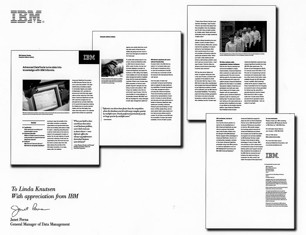
IBM Customer Success Article
IBM honored Advanced DataTools’ work implementing fast data warehouses to support decision-makers, our long relationship with Informix (from its product launch, over 35 years ago), and our benchmarking of various database products, comparing Informix to other database industry leaders with this article signed by then-General Manager of Data Management, Janet Perna.
Performance Tuning Accomplishments
For a flash memory manufacturer:
The 24x7 Informix database systems that operate and monitor this client's chip fabrication plant were aging and struggling to maintain operations in the face of increasing demand for its products.
Advanced DataTools' server configuration tuning and physical schema reorganization of the systems and databases improved performance sufficiently to permit this client to extend the life of their current hardware and software for three additional years. Savings included ~$90,000 in licensing costs plus savings associated with running for three additional years on fully depreciated equipment. Ultimately these improvements, and careful design of the new systems three years later, reduced the upgrade software licenses and new hardware costs by several hundred thousand dollars.
For a US Government agency:
The agency was continually outgrowing the SAN storage systems for their data warehouse.
Advanced DataTools redesigned the database and physical storage schemas, delaying the need for additional storage subsystems for three years and saving over $1 million from the agency's budget.
For a US Federal District Court System:
Advanced DataTools redesigned their disaster recover and data replication strategies, and tuned the Informix server configuration. This enabled the client to increase performance while remaining on existing hardware through the federal government budget crisis.
For a major sportswear retailer:
The retailer had contracted to purchase competing retail locations, nearly doubling the number of outlets they would have to supply with merchandise from systems that were taxed even at current levels.
Advanced DataTools recommended improvements to the database schema and application code, and tuned the Informix server. After struggling to produce timely restocking reports, within two months these improvements enabled the client to double its sales volume and store count.
For a regional bank:
The bank was suffering when their new, upgraded banking systems hardware began to timeout transactions during interbank ATM processing, which caused internal retransmissions and slow response times.
Advanced DataTools tuned the operating system, storage subsystems, and Informix configuration, which eliminated the interbank ATM transaction failures and improved response times for the bank's tellers and customers. The improved customer satisfaction and staffing cost savings were worth many times the cost of the Performance Tune-Up.
For a major manufacturer of telecommunications systems:
The manufacturer developed products using the Informix database. To make the product more profitable, the need was to increase the performance and scale of the database without increasing hardware costs.
Advanced DataTools' investigations into internal bottlenecks and database performance resulted in reduced production costs, increasing profits significantly. With one of the products, Advanced DataTools reduced CPU usage by 25%.
For a major credit bureau:
After acquiring a small credit bureau, the parent bureau decided to use the acquired bureau's Informix database systems for their account servicing. The additional data and transaction volume overloaded a database that was designed for a much smaller data and user environment.
Advanced DataTools provided Informix server configuration tuning and schema modifications, as well as developer training. This resulted in improved user experience, a 50% reduction in delays answering customer inquiries, and avoided the need to purchase larger, more powerful hardware.
For a private university:
Advanced DataTools' database schema redesign and Informix configuration tuning enabled the client to replace aging equipment with its high maintenance costs with modern low cost server. This required a far smaller maintenance investment for less than the cost of a single year's maintenance budget. Student experiences were also improved.
Customer Testimonials
Consulting
"Advanced DataTools partnered with the Action Alliance to build the nation’s first secure web-based data collection system for agencies providing vital and life-changing services to survivors of sexual and intimate partner violence. This system has stood the test of time—adapting to the changing needs of the field, providing valuable reports to improve services locally and statewide, and continuing to provide round the clock secure services. As a result of this partnership, Virginia’s sexual and domestic violence agencies have been able to dedicate more time and resources to services and prevention programs each of the last 20 years. Thank you!"
~ Kristi VanAudenhove, Executive Director, Virginia Sexual & Domestic Violence Action Alliance
"Without Advanced DataTool's invaluable assistance to our data warehouse efforts, FSA would be years behind on our current deployment schedule. The personnel from Advanced DataTools are well-trained and meet FSA's needs for time and cost savings in our complex data warehouse efforts. "
~ Jeffrey O'Connell, CPA, USDA, Farm Service Agency, Kansas City Finance Office
"Decision makers can identify which offices or programs are accomplishing the best results at the lowest costs and use that information to improve their business practices."
~ Terry Brokovich, BLM Project Manager
“[The] 2001 Domestic Violence Report presented astounding information and statistics.”
~ Tim Kaine, Lieutenant Governor of Virginia
"Thanks so much for making the 1614 data easy to understand and easy to use while retaining about as much of the detail that you could. It's rare that both can be accomplished at the same time. The combination of smart database design and good documentation allowed us to analyze [it] in a matter of hours..."
~ quote from a USDA Farm Service Agency 1614 Database user
Training
"The Advanced Performance Tuning class helped me to gain a much deeper understanding of how to analyze and troubleshoot database performance issues.The topics that we covered will also help me to make smart decisions for designing and building new databases and servers.I am very pleased with the amount of information that Lester and Art were able to pack into a 4-day course.Their depth of knowledge and experience make this class worth every penny."
~ Ryan Hughes, Choice Hotels International
"I recently had the opportunity to attend (remotely via WebEx) a training course with Lester Knutsen for Informix. This was one of the best investments that we have spent on learning tips to tune and monitor a system. The course was very informative and enlightening. At first, I was skeptical of attending a training session remotely but in the long run it was definitely the best way to have been trained. We were able to immediately make checks, changes, and adjustments to our current infrastructure as the course was being taught. Thanks for all your support and help!"
~ Eric Urff, Director Information Technology, Daytona State College
"Lester’s Advanced Informix Performance Tuning course not only helped us identify performance bottlenecks in our OLTP environment but also address them and put control back in our hands, not the other way around."
~ Eliezer Nebab, Lazare Kaplan International Inc.
"This was a great class... we will be upgrading from version 10.00 to 11.70... Lester and Art are great instructors, made the class fun and their depth of experience with Informix and IT in general is very impressive. The upgrade that we will be performing in the coming months was made much easier and it's because of this class…"
~ Bill Chick, Advanced Informix Performance Tuning Course participant
Key Legacy Customer Accomplishments
Customer Appreciation Awards
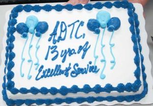
In 2011, the USDA Farm Service Agency honored Advanced DataTools with an "Excellence in Team Work" award for 13 years of successful teamwork implementing the FSA's expansive data warehouse. It was a generous and lively celebration with cake, speeches, and the gift of several framed photographs we proudly display on our office walls.

In December 2008, Advanced DataTools was deeply honored to receive VSDVAA's 'Act, Honor, Hope' appreciation award "for a decade of partnership to improve Virginia's response to sexual and domestic violence" through the VAdata Collection System. The award states "Thank you for 10 years of a vibrant and respectful partnership that has yielded groundbreaking results."
VADV also received a letter of recognition in 2002 from Virginia's then-Lt. Governor Tim Kaine for the VAdata application's contribution to "bring[ing] about change in the lives of victims."
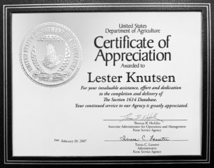
2007 USDA FSA 1614 Appreciation Ceremony. FSA employees and Advanced DataTools were recognized for the enormous effort required to implement the 1614 Database, as directed by Congress, to track the benefits under Titles I and II of the 2002 Farm Bill.
In 2007, the 1614 database contained 64 million records for more than 2.3 million entities or individuals, and provides information on approximately $56 billion worth of benefits to American farmers.
USDA Farm Service Agency (FSA)
Advanced DataTools built 18 data marts for the Farm Service Agency over our 11-year contract.
Financial Inquiry Web Site
In 2001, the Farm Service Agency launched the FSA Financial Inquiry Web Site, developed by Advanced DataTools working closely with FSA developers, which completely changed the way farmers and farm producers keep track of the status of their financial loans.
Brio Achievement Award for Best Government Solution
In 2002, the USDA Farm Service Agency received the Brio Achievement Award for Best Government Solution. Advanced DataTools worked with FSA to implement a reporting system using Brio to improve accounting operations management, and provide quick data access, accurate reporting, and significant time and labor savings for over 10,000 staff.
DOI Bureau of Land Management (BLM)
Advanced DataTools developed and has supported applications for the Bureau of Land Management for over 20 years.
Collection and Billing System
On September 1 2004, the Bureau of Land Management's Collection and Billing System, which was developed by Advanced DataTools in October 1999, hit an important milestone when it reached the $1 billion mark in deposits for FY2004. The Bureau of Land Management is one of the largest sources of revenue for the US Federal Government. Advanced DataTools teamed up with BLM personnel to develop the web-based collection and billing transaction system, which allows BLM to enter every dollar collected into one centralized system.
Management Information System Finalist for the President's Quality Award Program
In 2002, the Bureau of Land Management’s Management Information System was selected as one of 7 Finalists out of 100 for President [Bush]’s Quality Award Program. Advanced DataTools provided the software design, development, and implementation consulting support to build the IBM Informix and web-based financial MIS. The MIS data warehouse provides reports to over 7,000 program staff, financial analysts, and budget staff in 300+ field offices.
Budget Planning System
In 2002, the Bureau of Land Management’s Budget Planning System (BPS) was designed to streamline the BLM’s budget process and enable them to compete effectively for a budget that would support their programs and goals. Advanced DataTools developed BPS in two phases.